
Biodiversity
Sri Lanka became a party to the Convention on Biological Diversity (CBD) by signing the Convention in June 1992 and ratifying it in March 1994. The Ministry of Mahaweli Development and Environment is the National Agency designated for the CBD.
As a Party to the CBD, especially under Article 18(3), the Government of Sri Lanka must set up and operate its National Clearing House Mechanism.
Further to decision X/15 of the CBD CoP, its mission is to contribute significantly to the implementation of the Convention on Biological Diversity and its Strategic Plan for Biodiversity 2011-2020 through effective information services and other appropriate means to promote and facilitate scientific and technical cooperation, knowledge sharing and information exchange, and to establish a fully operational network of Parties and partners.
To fulfil the above requirements, the Biodiversity Secretariat of the Ministry of Mahaweli Development and Environment established this National Clearing House Mechanism, and it plays a crucial role in promoting and facilitating scientific and technical cooperation and exchange of information among all stakeholders.
Physical Features
Sri Lanka is located at the southern point of the Indian sub-continent, between 5° 54′ and 9° 52′ North Latitude and 79° 39′ and 81° 53′ East Longitude. Its land area is 6,570,134 ha. Topographically, the island consists of a south-central mountainous region that rises to an elevation of 2500 m, surrounded by broad lowland plains at an elevation of 0 – 75 m above sea level. From the mountainous region, nine major rivers and 94 other rivers drain across the lowlands into the Indian Ocean.
The climate is tropical overall, but it shows variations across the island due mainly to differences in rainfall and elevation. The rainfall shows seasonal fluctuations and is dependent on the southwest and northeast monsoons and on convectional and cyclonic effects. The mean temperature in the lowland areas is 270C in the wet region and 300C in the dry zone. It decreases with an increase in altitude, and in the montane region, the mean monthly temperature varies from 130C to 160C, with the night temperature occasionally dropping to around zero.
The country has been divided into climatic regions in many different ways. Generally, three broad climatic regions are recognized: the wet zone, dry zone, and intermediate zone. Whereas the dry zone is all lowland, the other two zones are further subdivided on the basis of altitude. Further, the Island can be divided into a large number of agro-ecological regions based on the combination of the annual rainfall and its seasonal distribution, and the altitude.
Geologically, 90 percent of the island consists of Precambrian crystalline rocks. The other main rock types are Miocene limestone deposits that extend from the Jaffna peninsula and the adjoining offshore islands to the northwest coast as far as Puttalam and down the northeast coast to Mullaitivu, and a small area of Jurassic deposits at Tabbowa and Andigama, near Puttalam. The overlying soils are of many different types, but the red-yellow podzolic soils (lateritic red loams) in the wet region and reddish-brown earth in the dry zone are the most common.
Geomorphologically, Sri Lanka is part of the ancient continent of Gondwanaland. India and Sri Lanka broke off from the disintegrating continent as what is called the Deccan Plate, and, as this plate drifted northwards, the two countries became isolated around 20 million years ago. Sri Lanka has retained its present outline for the last ten million years, since the end of the Miocene. Today, Sri Lanka is separated from India by the narrow Palk Strait, but it is likely that there had been oscillations of the relative levels of the land and sea resulting in land connections with India for short periods.
Sri Lanka, despite its small size, has a rich diversity of soils. Fourteen of the Great Soil Groups have been recognized within the country. The Great Soil Groups in the dry zone and the drier part of the intermediate zone are Reddish Brown Earths (occupying the largest area), Low Humic Gley Soils, Non-calcic Brown Soils, Red-Yellow Latosols, Alluvial Soils (in the flood plains of the larger rivers), soils of the Old Alluvium, Solodized Solonetz (in the arid areas), Regosols (in the coastal areas), and Grumusols and Rendzinas which are found in relatively small extents.
The Great Soil Groups in the wet zone and in the wetter parts of the intermediate zone are the Red-Yellow Podzolic Soils (which is the dominant type), Reddish Brown Latosolic Soils, Immature Brown Loams, and Bog and Half-bog Soils (found mainly in the tidal marshes).
History and Culture
The recorded history of Sri Lanka goes back to the advent of Indo-Aryans from India in 543 BC. Until the sixteenth century AD, the country had an independent, monarchical system of governance. From 1505, the maritime areas were dominated successively by the Portuguese, Dutch and British. In 1815, the British assumed control of the entire island after they annexed the central kingdom. Sri Lanka regained political independence in 1948 and became a Republic in 1972.
During the time of monarchial rule, the concepts that we now recognize as biodiversity conservation were ingrained in the cultural and religious beliefs of the people of Sri Lanka. According to the Mahavamsa, the great chronicle of Sri Lankan history, the protection of forests and animals was esteemed highly by both rulers and subjects. This respect for all forms of life is fostered by Buddhism which spurns animal slaughter. As far back as the third century BC, wildlife ‘sanctuaries’ for the protection of fauna and flora existed in this country, while the concept of ‘urban nature reserves’ was promulgated in the twelfth century AD.
With the onset of the colonial era, there was a dramatic change in the cultural and socio-political climate in the country. During this period of foreign rule, there was large-scale destruction of the forests, particularly for the establishment of plantations. These activities marked the beginning of environmental problems and large-scale biodiversity erosion in the country. After gaining independence, clearing land for development schemes in the dry zone commenced and continued to gain momentum, causing a further loss of indigenous biodiversity. Despite these adverse trends, the concepts which underlie the conservation of biodiversity continue to influence the lives of rural people, particularly those of the older generation. Even today, certain species of trees are protected by religious beliefs. Ficus religiosa is considered sacred by Buddhists as the tree or ‘bhodhi’ under which the Buddha attained enlightenment; Mesua spp., bamboo groves, and Ficus benghalensis are some species that are held in high esteem by Buddhists; and the neem tree(Azadiracta indica) is revered by Hindus. Most rural people consider it irreverent to fell large trees, due to their belief that such trees are the abodes of lesser gods. Among the fauna, the elephant (Elephas maximus) plays a dominant role in the cultural and religious pageants of the country, especially in the age-old annual Esala Perahara (procession) in which about a hundred domesticated elephants participate.
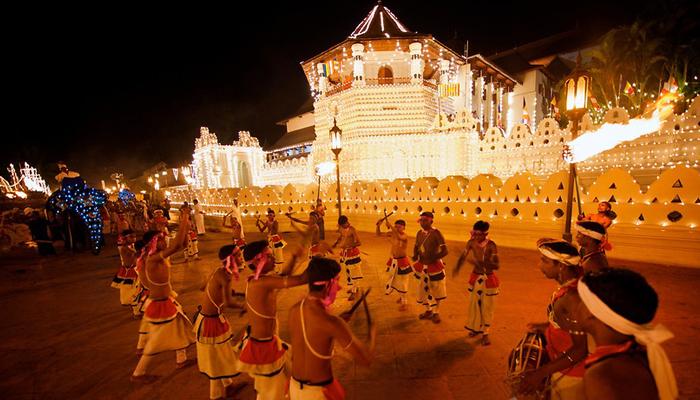
Kandy Perahera
Recent decades have seen a sharp increase in human population, and the overriding need to produce more food has exerted great pressure on the forests which were seen as a source of land for agriculture. There was also a growing tendency towards secularism. These factors, as expected, led to an undermining of the values which are an integral part of the cultural and religious heritage of Sri Lanka.
Agro-Ecological Regions
An agro-ecological region represents a particular combination of the natural characteristics of climate, soil and relief (Panabokke, 1996). When an agro-climatic map, which can be considered as areas where the integrated effect of climate is uniform throughout the area for crop production, is superimposed on soil and terrain the resulting map identifies agro-ecological regions. Thus, each agro-ecological region represents a uniform agro-climate, soils and terrain conditions and as such would support a particular farming system where certain range of crops and farming practices find their best expression.
In the Wet zone, there are 15 agro-ecological sub-regions. Four sub-regions found in the Up-country wet zone show a distinct variation in the distribution of the South West Monsoon (SWM) rains. Being in the most effective area of the SWM rains, WM1a, WL1a and WU1a sub-regions receive the highest amount of rainfall in the country. Apart from the amount and distribution of SWM rains, relative effectiveness of North East Monsoon (NEM) rains has also played a vital role in distinguishing 6 sub-regions in the mid- country wet zone. The four months period from December to March is relatively “dry” in WM3a agro-ecological sub-region while there are two distinct dry periods in the WM3b due to reduced effectiveness of SWM rains over this sub-region. In the Lowcountry Wet zone, amount and distribution of SWM as well as First Inter Monsoon (FIM) rains were important in identifying the 5 agro-ecological sub-regions. Meanwhile, the months July, August and December in WL3 agro-ecological region does not receive adequate amount of rainfall and hence cannot be considered as wet months. As such, 4 months period extending from December to March is relatively “dry” in this region.
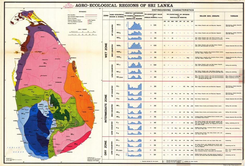
Agro Ecological Regions in Sri Lanka
The Intermediate zone consists of 20 agro-ecological sub-regions out of which 15 subregions are in the central hills. Varying degree of effectiveness of different rainfall governing mechanisms across the central hills has caused variety of growing environments in this region. There are 7 agro-ecological sub-regions in the Up country Intermediate zone out of which IU1 is reported to receive the highest annual rainfall among all sub-regions of the entire Intermediate zone. Being in the Knuckles range, this region receives ample amount of rains from NEM while the contribution from SWM rains is also substantial. Complex geographical settings of the IU3 agro-ecological region which encompasses almost whole of the so-called “Uva basin” have resulted 5 agroecological sub-regions due to high spatial variability of intermonsoonal and NEM rains in this region. Meanwhile, being located in the rain shadow area of the SWM, this region does not receive adequate rains during June to September resulting in dry and windy environment. The Mid country Intermediate zone has 7 agro-ecological sub-regions. Most of these sub-regions also do not receive adequate rains from SWM and, hence, 4 months period from June to September is relatively dry. Low country Intermediate zone consists of 5 agro-ecological sub-regions. Other than IL2, all other agro-ecological subregions in the Low country Intermediate zone resemble a bi-modal rainfall distribution. Since Second Inter Monsoon (SIM) and NEM rains are the only effective rainy seasons in the region, the IL2 agro-ecological region exhibits a distinctly uni-modal rainfall distribution along with a long and pronounced dry period from April to September.
In the Dry zone, there are 11 agro-ecological sub-regions with different rainfall distribution and edaphic features. The DL3, DL4 and DL5 agro-ecological regions of the Dry zone receive the lowest annual rainfall of the country in combination with some soil limitations that are found in these regions. Out of 11 agro-ecological sub-regions, only DL1a and DL1b are characterized by two discernible peaks in the rainfall distribution and thus, support crops in both Maha and Yala growing seasons. Those agro-ecological subregions found in the eastern sector of the Dry zone, i.e., DL1c, DL1d, DL1e and DL2a and DL2b, exhibit a distinct uni-modal rainfall pattern, and support only the crops in Maha season. The rest of the agro-ecological sub-regions of the Dry zone also support only the Maha crop since Yala rains in those sub-regions are not adequate to meet the evapotranspiration requirements.
Agro-ecological Zones
Sri Lanka has a heterogeneous agro-ecological environment and many workers have made efforts to classify this situation. A particular agro-ecological region represents fairly even agro-climate, soils and terrain conditions and would support a particular farming system with a certain range of crops and farming practices, including forage cultivation and livestock farming.
On rainfall distribution, Sri Lanka has traditionally been classified into three climatic zones viz; the Wet Zone, Dry Zone and Intermediate Zone. The Wet Zone covers the south-western region including the central hill country and receives relatively high mean annual rainfall over 2,500 mm without pronounced dry periods. The Dry Zone covers predominantly the northern and eastern part of the country, being separated from the Wet Zone by the Intermediate Zone. The Dry zone receives a mean annual rainfall of less than 1,750 mm with a distinct dry season from May to September. The Intermediate zone receives a mean annual rainfall between 1,750 to 2,500 mm with a short and less prominent dry season.
In differentiating these three major climatic zones; land use, forestry, rainfall and soils are widely used and as a result, they were divided into 24 agro-ecological regions. Environmental change, availability of more spatial and temporal data and advancement of GIS technology has led to the sub-division of the 24 agro-ecological regions of Sri Lanka into 46 sub-regions.
Conservation in Ancient Sri Lanka
In centuries past, during the time of the Sinhala Kings, forests and animal life were an important part of the social fabric. They were accorded a special status and protected under the law of the land. Commenting on this aspect of social life, John D’ Oyly (1835) states that ”Within Mahanuwara itself there was no doubt that the forest was strictly interdicted as a royal preserve – the ditch marking the limits of the city went round the king’s great thicket, Udawattekale, and people were not allowed even to gather firewood and withes in it.”
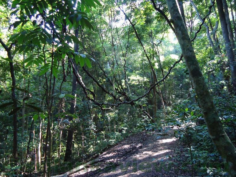
Udawattakele
Like the Udawattekalle, other forests were also owned directly by the king, and considered Crown property or Rajasan taka. Any sort of activity within these. Tahansi Kalle”, or ”Forbidden Forests”, was strictly prohibited. Almost every province of the Kandyan Kingdom had several such ”protected areas”, where any kind of cultivation, felling of trees, hunting or fishing were strictly prohibited, and punishable by a heavy fine. The king ensured that these laws were enforced by a regular Forest Department, comprising the ”Kalle Korales” appointed by him. It was the duty of these officers to ensure that the Crown forests were not damaged in any way.
Historical chronicles record that animals, too, were given special protection. The ”Niti Nighanduva”, which is the repository of ancient Sinhala law, records that all elephants were regarded as the property of the Crown, and killing an elephant was perceived as one of the most atrocious of all crimes. In keeping with the prevalent social fabric, hunting and killing of animals appears to have been generally looked down upon, for the ”Niti Nighanduva” statesthat animal slaughter was outlawed during the last 50 years of the Kandyan Kingdom, on the grounds that it was contrary to Buddhist principles.
Respect for forests and all forms of animal life was thus not only deeply enshrined in the moral and legal codes of the ancient Sinhalese, it was also a part of their way of life. When the British began clearing the forests in the mid 19th century, it destroyed an ancient society and a way of life which had existed since the coming of Buddhism to Sri Lanka in the third century B.C.